Sometimes a fantastic idea hits you in a millisecond – and that’s just happened to me at Coffee in the Chemistry Department. I happened to bump into Mark Calleja (who is part of our eScience (eMinerals) collaboration) and he told me about their latest project (Cambridge Mobile Urban Sensing)
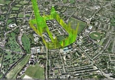
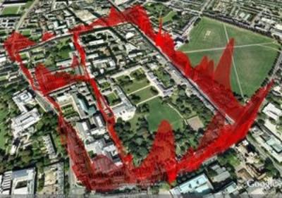
CamMobSens is the Cambridge end of the MESSAGE project, a collaboration between Cambridge University, Imperial College London, Leeds University, Newcastle University and Southampton University. In Cambridge we mount sensors on pedestrians and cyclists to monitor pollution and send back the information to a website as soon as it is gathered.
Nitric Oxide (NO)
Team members:
|
|
Now anyone who knows anything about OpenStreetMap.org will immediately make the connection – as I did. OSM has been built by the voluntary efforts of zillions of pedestrians and cyclists who have used GPS to map the world. They’ve now built the best map of Cambridge and at least one has cycled every street.
Mark and colleagues need volunteers to go out and monitor pollution on a regular basis. The technical aspects are solved – a mobile phone in one pocket and a sensor in the other emitting Bluetooth. The signal is routed to satellites and then to an Openly accessible database run by the project. All you have to do is follow the simple instructions of the project.
So I’ve asked Mark if I can be first on the list for the kit – volunteer activity starts in late summer. I cycle every day down East Road (at the top left of the CO picture). It must be one of the most polluted roads (although the bus station is worst).
So I am appealing to OSM volunteers IN CAMBRIDGE to contact Mark. (The idea is clearly adaptable to other cities but we shouldn’t overwhelm the project at this stage). If you know how to spread the word in the OSM and similar communities, please do so. There is no technical reason which this couldn’t rapidly spread just as OSM has done.
Pingback: glynmoody's status on Thursday, 25-Jun-09 10:00:33 UTC - Identi.ca
Pingback: Unilever Centre for Molecular Informatics, Cambridge - The Guardian highlights the eScience pollution project « petermr’s blog
Join the IRC #osm channel on OFTC (via http://irc.openstreetmap.org ) or Sign up to the http://lists.openstreetmap.org/listinfo/talk list and ask your question there.
Or just use the OpenStreetMap tiles to overlay your information.
http://wiki.openstreetmap.org/wiki/Tile_usage_policy
@Grant YES. Everyone should join OSM. It’s not just about coordinates, it’s also about streetnames, buildings, etc. You don’t have to be a geek to help.