Well! My appeal for volunteers for the pollution project came in a most unexpected way – it was picked up by the Guardian. The Guardian are champions of Open data (“Free Our Data”) and as you read their report of my blog you’ll see the considerable and valuable amplification about the role of OpenStreetMap. (I didn’t highlight this aspect although I have praised OSM before). I’ll quote almost all (without permission, but as fair use): of http://www.guardian.co.uk/technology/2009/jun/25/cambridge-pollution-monitoring-mapping
A chance encounter in the coffee lounge of the Cambridge chemistry department could lead to real-time maps of pollution in the city, as an offshoot of an EU project that is nearing completion in the city.
A team in Cambridge which has been running the Cambridge Mobile Urban Sensing project (CamMobSens) will begin equipping volunteers on bicycles and on foot with mobile phones and pollution sensors linked by Bluetooth.
The sensors will monitor the levels of carbon monoxide and NOx (nitrogen oxides) in the city air and relay them to satellites, which will pass them directly to openly accessible databases being run by the project.
The government does provide an overview of air quality at its own site, airquality.co.uk, but the data is not real-time, and is not mapped in detail, although it is possible to get a Google Earth download which will show the air quality as measured by roadside monitors.
But Professor Peter Murray-Rust, who happened to meet Mark Calleja, the head of the CamMobSens project during a coffee break, has now suggested that the results could be mapped in real time onto the free open-source maps provided by the OpenStreetMap project, a British-inspired project which uses volunteers using GPS locators to create maps of cities and, in time, countries.
Murray-Rust is now appealing to the OpenStreetMap team to get in touch with Calleja, so that by the time the project begins later this summer it will be possible to add the pollution information immediately to maps from OpenStreetMap.
The advantage of using OpenStreetMap rather than online maps from the UK’s official mapping agency, the Ordnance Survey, is that there are no copyright implications in the addition of data to the maps – and no limits or charges on viewing of the maps. Ordnance Survey has recently eased its restrictions on non-commercial organisations using custom online maps through a specialised web interface, but issues remain over its licensing of unrestricted access to those maps.
If it succeeds, it won’t be the first time that Cambridge’s university coffee has had a dramatic effect. In 1991 a group at the Cambridge Computer laboratory aimed a webcam at a coffee pot downstairs from their laboratory so that they wouldn’t have to walk downstairs to find out if it was empty or full. The webcam was later put onto the world wide web – and engineers at Microsoft showed it to Bill Gates in 1994 to persuade him that the web would be important by making it feasible for people anywhere to stay in touch – even with their coffee pots.
PMR: thanks Charles and the Guardian. A responsible and readable account. [I should make it clear that Mark Calleja is not the project leader.]
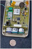
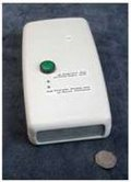
I asked Mark for pictures of the sensors and he replied:
Here are two pictures of a sensor (note coin for scale [ca. 1.8 cm diameter]), and one of the sort of phone we use (Nokia N80, and O2 give us free SIM cards to use).
 I gather that the Guardian article has got people interested in collaborating – please don’t approach me but the project as posted yesterday.